|
|
|
|
|
|
| Noon Positions | Geographical Area | Pages Read |
| N/N 51° N 1° E | Ramsgate | 300 |
| N/N 49° N 5° E | Bay Of Biscay | 600 |
| N/N 44° N 10° 10° W | Bay Of Biscay | 900 |
| N/N 38° N 9° W | Lisbon | 1,200 |
| N/N 28° N 15° W | Canary Isles | 1,500 |
| N/N 26° N 12° W | Cape Verde Isle (Entering the Doldrums) | 1,800 |
| N/N 22° N 19° W | Cape Blanc | 2,100 |
| N/N 9° N 18° W | Sierra Leone | 2,400 |
| N/N 0° N 10°W | CROSSING THE LINE | 2,700 |
| N/N 8° S 3°W | The Gulf Of Guinea | 3,000 |
| N/N 15° S 5°E | St Helena Isle | 3,300 |
| N/N 22° S 12° E | Tropic of Capricorn (Leaving the Doldrums) | 3,600 |
| N/N 33° S 18°E | Capetown Cape-Of-Good-Hope | 3,900 |
| N/N 33° S 27°E | East London (West Coast Africa) | 4,200 |
| N/N 30° S 38°E | Near Madagascar (Mozambique Channel) | 4,500 |
| N/N 20° S 57°E | Indian Ocean ( Near Mauritius) | 4,800 |
| N/N 18° S 70°E | Rodriguez Isle | 5,100 |
| N/N 17° S 80° | Indian Ocean "Water Water everwhere" | 5,400 |
| N/N 12° S 97°E | Near Cocos Isle | 5,700 |
| N/N 6° S 106°E | Near Djakarta (Sumatra) Krakatoa!!!!! | 6,000 |
| N/N 10° N 110°E | South China Sea (Off Borneo) | 6,300 |
| N/N 23° N 120°E | Formosa (East China Sea) | 6,600 |
| N/N 26° N 119°E | Foochow | 6,900 |
| Each player can be represented by a small clipper
icon
(named or
numbered) which could be fitted with some adhesive
property (perhaps a
magnet) and their progress could be indicated weekly on
a large board
divided
into sections as below. You need
a wall for this but if you wish to
leave
this bit out... look at the spreadsheet
option |
| 1 | 2 | 3 | 4 | 5 | 6 | 7 | 8 | 9 | 10 | 11 | 12 | 13 | 14 | 15 | 16 | 17 | 18 | 19 | 20 | 21 | 22 | 23 | 24 | 25 | 26 |
Example:--- Sheet 1 from the above set of 26 sheets (A0 size sugar paper)

|
|
|
|
|
|
| Each sheet would be divided as above and the pupils could be represented as small ship-shapes and stuck on with blue-tack (we used magnets on a metal radiator). |
When the pupil has read 300 pages they move to the next sheet.
You
can
make the game even more demanding by making each player read a set
number
of pages to "Clear the port of London" .
|
Readers can travel faster if they are reading
something pertinent
to the area they are travelling in. That is if you are
reading about
the
slave trade and that is your location add 10 degrees.
Readers could be
employed in some activity related to every sheet. e.g.
If a reader
reaches
the Ramsgate N/N position allow them to wear holiday
clothes for a day.
There are all sorts of possibilities in this area. It
would also be
possible
to select out several random rewards every week ...
i.e. "favourable winds mean you are able to
make
greater
speed ...
move on two degrees " the bay of Biscay was calm today
move on a
degree"
etc., and.... also.....penalties
Krakatoa is about to erupt make a course for safety. go back two degrees (unless you read about a volcano) etc., |
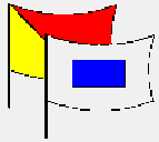
| We also included graduated movement through the ranks as below. The ranks were noted on a badge and just to keep up the theme the badges were designed using the signal flags for the grades: i.e. A Deck Hand would be given a badge with the signal flags DH displayed on it and the child would be given a small badge with the signal flags JOS when they had read 1,200 pages. The flags were easy to make using paint-brush and two out-lines and a colour printer. The official signal flags are in many books usually around the Morse-code sections.... |
| Ratings we used on the
voyage:- Please see example badge for Ordinary Sailor O/S I have pictures of all the badges if you require them. |
 |
| 600 Pages | Deck Hand |
| 1,200 Pages | Junior Ordinary Sailor |
| 1,800 Pages | Ordinary Salior |
| 2,400 Pages | Able Bodied Salior |
| 3,000 Pages | Petty Officer |
| 3,600 Pages | Middy (Apprentice Deck Officer) |
| 4,200 Pages | 4th Officer |
| 4,800 Pages | 3rd Officer |
| 5,400 Pages | 2nd Officer |
| 6,000 Pages | 1st Officer |
| 6,600 Pages | Master |
| 6,900 Pages | Extra Master |
At school I also designed a book of spread-sheets in Excel that listed all the names of all the classes involved and ran to 8 pages (one for each group of children)
The spreadsheet is easy to make. You simple divide it up into 26 sections. Each section is headed by the noon position of that sheet (see above) each section is 5 cells (it's quite long) and when a child has completed 60 pages simply insert a mark in that cell. We used an icon of a book (it's one of the icons that is available in Excel). The spreadsheet was a good idea as it was possible to network it through the school and let children log on anywhere to see how they were doing. Being such a big project we got two pupils to collect weekly reading scores off the form tutors and input them onto the sheet.
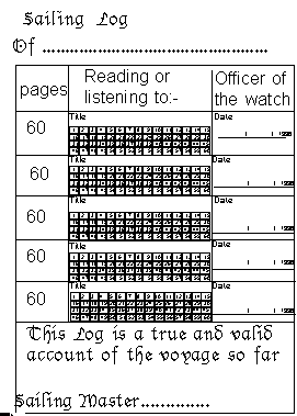
As a back up to the board race and the spread sheet I also
designed
a small "Sailing log" that was divided into a five degree page
something
like this
 |
|
| The pages were divided up into 60 small squares and the
children kept
shading in each square till they reached 60 and then got
an adult to
sign
it (if the adult was satisfied that the reading/listening
had been
done)
If you find this idea useful please feel free to implement
it at your
school.. Roger |